There are numerous apps that make your everyday life as a drone pilot easier. We have compiled the best apps for drone pilots for you and present them briefly in an overview.
What characterises a good app for drone pilots?
When selecting suitable apps, we focussed on finding apps for drone pilots that make everyday flying easier. These include, for example, apps that offer new functions for your drone, provide you as a drone pilot with additional information for your drone flight or help you to better plan your drone flight and document your flights.
You are welcome to name your favourites in the comments and discuss other useful apps. We will update this list regularly and look forward to your recommendations.
Caution! Never rely solely on the information provided by an app. Laws, weather and other circumstances can change regularly and quickly. Always obtain information directly on site and from other sources to be certain. You should always view the apps as a support , never as your only source of knowledge!
Overview of the best apps for drone pilots
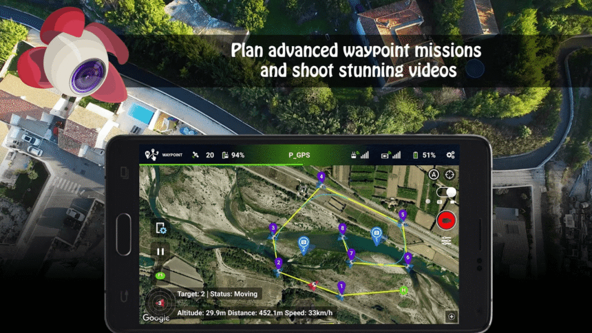
Litchi
Litchi is a paid app for DJI drones. Among other things, Litchi can be used to create waypoints for drones that do not support this function as standard in the official DJI Fly app. The app also includes its own “Active Track” system. This allows older drones that do not have the feature to be retrofitted with this function. The app also offers a “Focus Mode”, which allows both the drone and the gimbal to be controlled by the app, while you only have to make horizontal movements yourself. In this way, depending on the desired subject, you only have to concentrate on one control and can therefore focus on the actual subject. Another feature is the “panorama mode”, which can be used to create unique shots.
The app costs around €30 and is available for both Android and iOS. Please note: Litchi only supports certain DJI models. There is also a beta version of a new Litchi app with support for other models.
Windy
Windy is a versatile platform for weather forecasts that can also be useful for drone pilots. After all, the weather is an important factor when planning and carrying out drone flights. The app offers:
- Detailed weather data: Information on wind speed, wind gusts, temperature, air pressure and more.
- Map-based visualisations: Interactive maps that make it easier to understand the weather conditions in specific regions.
- Free of charge: The basic version is free of charge and already offers a wide range of useful data.
SolarWatch solar curve
The SolarWatch app shows the exact course of the sun for any location and any time. Thanks to the clear display of sunrise, sunset and the position of the sun over the course of the day, the app enables precise planning of drone flights.
SolarWatch is particularly valuable for drone pilots: whether for perfect lighting conditions for photo and video recordings or to avoid glare and shadows – the app helps to find the optimum time for the flight.
- Live view of the course of the sun with augmented reality
- Precise data for sunrise and sunset
- Planning options for future dates and locations
Adobe Lightroom
Adobe Lightroom allows you to edit photos quickly and easily on the go, even without a subscription. Especially if you save your drone shots in RAW format, you have a wide range of options for adjusting the exposure and colours or selecting the right section. Many presets help to give your pictures a certain look with just one click. With a subscription you get a variety of other functions at your fingertips. All in all, Lightroom provides everything you need to develop your images.
skyzr
Not yet directly available as an app, but already usable on mobile devices, our skyzr platform offers you a variety of functions for your hobby or your work as a drone pilot. Started as a pure job placement service, you can now find additional functions such as weather information, a digital authorisation service that allows you to fill out applications online, a public drone pilot directory in which you can optionally register to be easily found, a digital flight log to document your flights and much more.
Registration with skyzr is free and some of the functions can already be used. Further functions are available in various subscription options – all 14 days can be used free of charge to get an impression.
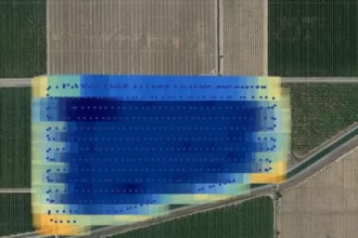
Drone Harmony for DJI drones
With Drone Harmony for DJI drones from the developer of the same name, it is possible to create a professional flight plan in 3D on a tablet or smartphone. The drone then flies this automatically and optimises the flight path. The app is therefore ideal for drone pilots who need a simple app to create routes that are then flown by the drone. This allows routes to be planned in advance and flights to be partially automated, which can be a huge help and make work much easier, depending on the job. This app is primarily used for inspection flights.
Drone Harmony is available free of charge in the Play Store in a slimmed-down version and, as the name suggests, requires a supported DJI drone. The full range of functions is only available with a paid subscription. You can also find tutorials and a list of supported DJI drones on the site.
Drone Harmony for DJI drones for Android


 19.11.2025 //
  16 – 17 Uhr //
  Digital